November is expected to be warmer than usual over the whole country with highest probabilities for warmer temperatures over the Central and Eastern parts of the country.
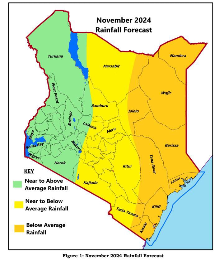
According to the November forecast released by the Kenya Meteorological Department, the Northeast and the coastal regions of the country are expected to experience below-average rainfall with poor distribution even as the short rains season enters its peak month of November.
The Director of Meteorological Department Dr. David Gikungu in the monthly forecast is warning that owing to depressed rainfall, there could be cases of human and wildlife conflicts, “especially over the eastern sector of the country where depressed rainfall is expected as animals migrate in search of pasture and water, some areas like in the northern part of the country could experience dust storms,” he says.
The Weatherman warns that some areas could receive isolated storms and dry spells during the month, “the Highlands east of the Rift Valley, including Nairobi, the southeastern lowlands, and some areas in the Northeast are expected to receive near to below-average rainfall,” says Dr. Gikungu.
The monthly forecast further indicates that the Lake Victoria Basin region, the Highlands west of the Rift Valley, the Central and South Rift Valley, most of the Northwest, and isolated areas in the Northeast, particularly the western parts of Marsabit, are likely to experience near to above-average rainfall.
The Weatherman is urging for caution in area including; the Highlands West of the Rift Valley especially in Kisii, Kisumu, Nandi, Kakamega and Narok Counties as well as on Mt. Elgon and its environs where lightning strikes could be experienced.
While noting that the Kenya Meteorological Department is monitoring the obtaining weather patterns, Dr. Gikungu in the statement says that projections indicate that negative Indian Ocean Dipole (IOD) conditions are likely to continue through November, “Both La Niña and a negative IOD typically result in below-average rainfall over Kenya,” he says.
The Weatherman further notes that, the El Nino Southern Oscillation (ENSO) remains neutral, with Sea Surface Temperatures (SSTs) in the central equatorial Pacific being near to below average, the atmospheric indicators, including surface pressure, cloud cover, and trade winds, are also consistent with neutral conditions, “the forecasts suggest that weak La Niña conditions may develop from November and persist into early 2025,” says Dr. Gikungu.
Among the impacts arising from depressed rainfall in the Arid and Semi Arid Lands (ASALs) of the North East and North West, could be reduced livestock production in the due to poor pasture regeneration. While near to below normal rainfall coupled with poor distribution may negatively affect crop production especially over parts of the Central and eastern sectors of the country as well as the Coastal region.
The Director of Meteorological Department says the major river catchment areas for the country’s hydroelectric power generating dams over the Highlands East of the Rift Valley are expected to receive near to below average rainfall and warns that, “the water levels in these dams may drop gradually owing to the dry conditions experienced in October,” says Dr. Gikungu and adds, “close monitoring is necessary to ensure stable power supply.”
The Weatherman is calling for the need to ensure water harvesting of rain water that could be realized during the season so as to cater for the water needs as the season progresses.


